Chantrey Inlet, Nunavut


Since we left Kasba Lake Lodge back in mid July for our last resupply, we have made our way north through the tundra and across some of the most beautiful waterways in the world. Over this past month, we have seen and done a lot. Too much to include in this one blog, so this one will be more of broad overview of our final section, with more exciting stories and blogs to come when we have more time.
Leaving Kasba Lake, we had a beautifully calm and hot day. The calm lake allowed us quick crossing before jumping onto the Kazan River. The water levels on the Kazan were very high and the river was moving very fast. Fortunately, throughout our time on the Kazan, we only had one portage to do to avoid a nasty rapid early on, the rest of our time on the river was spent traveling down its large, fast flowing channels with easy whitewater here and there. Just about the best paddling anyone could ask for - nice weather and a strong current to push us along. With our extra time, we were able to capitalize on entering the best fishing of our trip (all the arctic waterways). Known for its record size Arctic grayling and lake trout, we resorted to letting the current do most of the work for us, while we took casts along the way. We caught many fish, so much so, we needed to force ourselves to put our rods away at times so we could actually make progress for the day - a pretty good problem to have we’d say.
The Kazan travelled through the last of the treeline for us. Day by day, we slowly saw the trees leave, patches here and there would appear on the hillside, but largely disappeared after we left Ennadai Lake. As we transitioned from the treeline to the tundra, with it, we began to see new wildlife and plants along our route. The Kazan offered us our first of many caribou, muskox, and more varieties of birds than we could keep track of.
The Kazan took a hard turn east and north on Angikuni Lake. We traveled north off of the river, headed upriver yet again to Carruthers Lake where we could jump over to the Dubawnt River watershed. This section proved to be more challenging for us than expected. Many of the bigger lakes we traveled through this area were very shallow and slow going as we dodged rocks and shallow channels. From Carruthers lake, we took a series of shorter portages to some smaller lakes. Along these portages, caribou antlers and even some muskox were found. From here, we crossed a decent sized lake to get to an unnamed river that flowed into the SE corner of Dubawnt Lake. Though a small river, we were excited to go down river on it.
We camped at the end of the lake and decided to tackle the river in the morning after already having a long day of portaging between so many lakes. Upon waking up the next morning, we began following what seemed like a decent river. Very quickly, our hopefulness faded as the river practically dried up to rocks. We knew quickly we were in for a very long day. From this point, we practically portaged our way up the Dubawnt Lake. Occasionally, the river would widen for a 100 yards or so where we could walk or paddle, but then we would need to portage yet again around the next choked section. This small river had 2 very small lakes that offered us about 1-3km of undisturbed paddling, the most we were able to do all day. Thankfully, as the river picked up some water and speed towards its end, there became more water channels, not able to be paddled, but walkable at least. This saved us some back breaking portaging and we graciously accepted it. Late in the evening, we approached about 1.5km from Dubawnt Lake and could see the large lake in the distance. The river was choked for its remaining distance, so we debated setting up camp and finishing the portage early in the morning, but ultimately decided we had already had a long day, why not get the remaining distance finished. So we lugged our gear slowly down the tundra to Dubawnt Lakes distant shores and set up camp just before sunset. We laid in the tent more exhausted than we had felt at any other part of the trip.
Dubawnt Lake, known for its late ice out dates had us nervous leading up to it. Fortunately, we got there just as ive had left and it offered us two beautifully clear and calm days to paddle its expanse. We followed its east shore, which started with some incredible esker hills and sandy beaches. It quickly transitioned to shores of crumbled rock of all sizes, almost Quarry looking up and down the hills and shores as far as we could see - a place you would hate to be forced to camp in bad weather!


The lakes clear and cold waters were outstanding and we saw thousands of lake trout rising as we paddled across the lake. Just about anywhere you looked on the lake as you paddled, you could groups of fins breaking the calm surface of the water. A fisherman’s heaven!
We camped at the lakes outlet, just before entering the Dubawnt River itself. Here at this camp, the number of bugs could be quantified only in billions, or inches thick. We are confident that is the most bugs we will ever see in our lives (hopefully never again). The small black flies covered everything we brought in thick layers and our tent turned into a moving black mass of bugs. To make matters worse, it was almost 90 degrees outside and no wind. To be in the tent, we roasted inside, but it provided at least some relief from the bugs (although thousands still made their way in with us on our clothes). We woke up the next morning to the same scene as the night before as it was still hot and windless. We packed up camp in record time, though our tent and packs gained a few pounds of dead bugs (what a horrendous smell those bugs were). Right away down the Dubawnt, we had our first rapid. We scouted and ran the rapid with the swarm of bugs from the day before still following us. Took us all day and a little wind later that evening to finally get the bugs back down to a manageable level.
The Dubawnt River flowed fast and clear like the Kazan, but now entirely treeless. We followed the swift current and shot some rapids until mid morning until we approached the rivers famed canyon section. The river got big quick and we easily found the exit from the river and began our longest portage of 4km along the rivers edge, following its spectacular canyon. The river narrows greatly in here and has steep cliff walls and pillars of rock protruding along its course through the canyon. The views made the length of the portage manageable. We shuttled our gear in a leap frog method along the shores and shortly before its end, decided to make camp on one of the most scenic places on our route - on top of a flat esker overlooking the canyon below. An early day in camp, but it seemed sinful to leave such a beautiful place in such a hurry. We spent the day exploring and admiring its beauty. We also did some fishing in its deep pools at the base of the rapids and found tremendous success with large lake trout on both a fly rod and spinning rod.
During the night, a freak storm came and went, with huge winds and constant thunder and lighting. As quick as it came, it left and we finished the remainder of the portage around the canyon on a cloudy, cold, morning. From here, we crossed Grant Lake, another incredibly scenic lake before rejoining the river on its north end. We ran most rapids along this river, only a few times we got out to line/walk around some complicated sections, otherwise we were able to enjoy some exciting whitewater along the remaining channels. Towards the end of the river, it runs through two larger lakes, Wharton, and Marjorie Lake. We crossed Wharton in good weather, though it had lots of turns and islands to complicate the navigation. On Marjorie, we were wind bound one day with strong north winds that held us tentbound until we could finally cross the next morning. The north end of Marjorie Lake was also a very scenic spot and the large Marjorie Hills rose high between the Dubawnt and our next river, the Thelon. Shortly before the Dubawnt River exits into the Thelon, the river passes through yet another impressive section known as the “Dubawnt Gates”. This is a very narrow river section with very large pillars that stand in the middle of the river and steep walls line the river bank. With so much water flowing through these narrows, the rapids were huge and not worth running. The river does a tight 90 degree turn with a very skinny and tall hill on its left. We opted to do a very short, but very steep portage over this hill to get to the rapids base, vs a longer, but flatter portage on the other side of the river. From here, we had a great float down the river to its end, where we set up camp for the evening.
Early in the morning, we flowed onto the Thelon Rivers wide confluence with the Dubawnt. A very sandy, beachy area. We had a very warm and windless day here. Though wide here, the Thelon gave us good current and we moved swiftly. We saw caribou in large quantities all along the hills and islands as we entered the Thelon. On just about every shore or island you could see them walking alone or in small groups.
After lunch, we entered the Thelon’s first big lake for us, Aberdeen. The lake was very shallow along its north shore, which made paddling challenging since this point of the trip, most of the wind was coming from north. The shallow waters forced us out further into the lake and its northern hills then provided us little wind protection. In the evening, we spotted something further up on the lake. As we got closer, we realized it was another person, a paddler! We met Martin and his dog Boris, a guy about our age from Norway who was doing an amazing solo trip from Great Slave Lake to Baker Lake. We stopped out in the lake and had great conversation. Close to the time we usually find camp, we found a great camp on a flat island and camped with Martin for the night. We had an incredible night sharing stories of our trips and more around a small fire we managed with pieces of driftwood scattered across the island. We stayed up much later than normal, but the company was great and as the sun set, we watched waves and waves of hundreds of caribou rise over the hill across from our camp and walk its beaches. Surely a day of our trip we won’t forget any time soon!
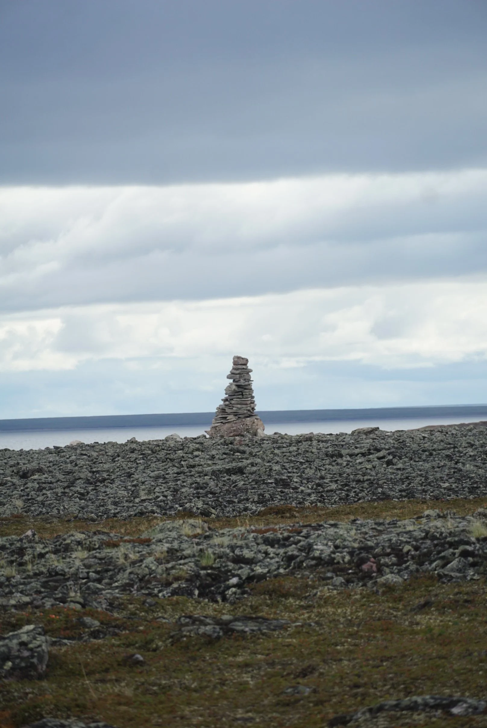
We spent the next few days finishing up the big lakes of the Thelon. For the most part, the winds were tricky side winds from the north, and finally on our last day on Aberdeen Lake, the north wind became too strong and we had to call it a windbound day shortly after lunch. The north winds brought cold temps off the Arctic Ocean. Bundled up, we fished from camp and caught some more beautiful Lake Trout. Our windbound camp also had several large Inukshuk’s and several old Inuit tent rings.
As we crossed the last big lake of the Thelon, Shultz, we saw a few motor boats from the community of Baker Lake (at the end of the Thelon) traveling to the few cabins on these lakes used by the locals for hunting and fishing. At the end of Shultz, the river narrows and has one last rapid of size that we ran part of and lined another part of. From here, for most paddlers, the Thelon is one big fast water slide down to the community of Baker Lake. Just like we had done so many times before on our route, we jumped off this route that is taken more frequently and made the difficult portages off the Thelon up to the infrequently paddled and much smaller, Meadowbank River. In the Thelon, we were getting close to sea level, but in order to get to the Arctic Ocean watershed from the Hudson Bay watershed, we needed to do several portages uphill to the Meadowbank headwaters.
After lunch, we started our uphill portages, most at least 1km in length, often more. The first “set” of portages brought us upstream a small river and its lakes. By this time of the year, virtually almost all of its waters were again dried, so any narrow channels, sometimes the big ones too were dry and we resorted to portages to get around them. A hot, buggy day got us a little less than halfway to the Meadowbank. The next day was similar, hot, buggy, and portages that lasted all day. These days got long and the heat of the day increased our frustrations with the already challenging uphill and long portages. We believe had all of this been earlier in the trip, it would have been much easier, but now getting close to 100 days on trail, we were getting beat down from these long days.
Slow and steady we hopped from puddle to puddle and reached the headwaters of the Meadowbank. This was a big moment for us as we could finally officially say everything from here was downstream from here. No more height of land portages or jumping watersheds. The excitement was short lived as the water levels at the headwaters were still merely trickles as we needed to wait for the river to pick up steam and water from tributaries further downstream. Several channels and areas early on the Meadowbank we needed to portage as expected. Slowly, the channels got deeper and faster and it began to look like a real river. The waters of the Meadowbank were exceptionally clear with a beautiful turquoise blue tinge to it.
The river was largely a series of bigger river sections or lakes that offfered little to no current connected by smaller river sections of quick flowing rapids, some runnable, most we walked or lined. The river, with lower water levels this late in the season had quite a few large boulders, holes, and ledges as obstacles in its rapids that required extra caution as we made our way down its course.
Between the river and the community of Baker Lake, there is an active gold mine in which they have created a road running further inland to move rock/dirt. This road unexpectedly crossed the river early on and we watched as convoys of mining trucks hauled loads of rock to the mines. The sounds of trucks and roads was an adjustment to our previous seclusion and quiet we had for quite some time. Fortunately, this was quickly past and we returned to the remote nature of the north.
The Meadowbank was a very rocky river, with either boulders of various sizes spread across the shore/hills or solid bedrock. As we descended it, it began to slowly transition into a more sandy and flat landscape. In one such area close to its end, we paddled through a very shallow and wide section of the river. We weaved around finding its deepest channels. Up ahead, we noticed a huge commotion and splashing. We quickly realized we were watching a pack of 6 Arctic wolves chasing down a cow and calf caribou in the sandy shallows of the river. Right in front of us, the mom caribou escaped into the deep river and swam across the channel. The calf caribou was less fortunate as we watched the 6 wolves very quickly and efficiently take down this young caribou. After the caribou had died, they pulled the carcass onto the edge of shore. By this time we were less than 40 yards from all of this and the wolves finally saw us. The pack walked down the shore and watched us pass by from the nearby hill. We were in shock and awe from what we were able to witness so closely.
We finished the Meadowbank in a wide river section that met with the also large Back River, our final river of the trip. The Back River known for its large amount of rapids and being one of the longest and most remote Arctic rivers for paddlers. At its confluence were large hills all around and a current that pushed us along, surprising for its size at this particular section. Though we were largely below the majority of the major rapids on the Back River, we did have a few rapids to run/line each day. Similar to some of our other rivers, this part of the Back was largely lake like sections with little current and connected by narrow sections of rapids or swift current. The Back is a huge river with much more volume than the Meadowbank and more comparable to the Kazan, Dubawnt, and Thelon’s flow. These rapids were much bigger because of its volume, so often we shot the sections that weren’t too big and either lined or walked the shores around any bigger stuff that wasn’t worth the risks.
With the section of the Back we paddled, it’s usually flowing in some northward direction. In days we had north winds, we had a tougher time making progress and the lake like sections offered little to no current to help us out. One afternoon, our progress came to a standstill with the wind, so we set up camp near the confluence of the Hermann River, which proved to be another one of the very scenic stretches of our route. Huge sandy esker banks with large meadows on top and sandy river valleys beyond. Many caribou were seen feeding throughout here and also some tent rings were found along the top near our camp
Getting close to the end and having several days with large north winds, we began to get anxious about making our pick up date in Chantrey inlet on the 19th. We had yet to paddle Franklin Lake, the largest lake remaining and the wide river sections leading north into the ocean. At the beginning of Franklin Lake, we woke up to find the lake calm as glass. We accepted the bugs on this warm and still day for some great progress across our last big lake. The lake does a sharp right turn and tumbles over Franklin Falls over several kilometers. These falls we were able to run some, walk most along the shore, and did a few short portages around ledges we couldn’t get around. The river drops quickly here and finished with two lower rapids that were smaller below the big falls. We ran these and quickly found ourselves just a few feet away from sea level.
In order to make our pickup date, we had done several very long days to ensure we would make it on time with the weather. On the evening of day 104, we reached our goal for the day, just a days paddle from the ocean and winds that were still very calm. Not willing to risk a change of weather that happens so quick this far north, we decided to pull over at what was supposed to be our camp and make some dinner. Over dinner, we decided that although we were both incredibly exhausted from the long previous few days, we should take advantage of the calm weather and push on into the night.
After a quick dinner, we repacked the canoe and bundled up with many layers to combat the coming cold weather of the setting sun and pushed off down the river. From here, we were done with rapids, the biggest challenge would be any shallow sections of sand as we got closer to the ocean. Navigating at night in the tundra can be incredibly hard in low light being that nothing is higher than a couple feet off the ground, so the whole horizon blends in and finding channels becomes difficult. Thankfully, if we stuck to the right shore, there were no real big bays or places where we could navigate off the river. We stuck as close to the right shore in the dark, staying just deep enough in the river. As the night progressed, we were blessed with a southern wind that was picking up and helping us along at a great speed. We stopped in the middle of the night for a “lunch” and break before we went for our final push. Both of us were doing what we could to stay warm on this cold night and doing our best to combat our heavy eyes that desperately wanted to sleep.
As we approached the end of the back river, the sun rise of day 105 was beginning to brighten the skies. The hills of earlier in the day flattened to sandy banks and big sandbars sticking out into the river we needed to paddle way out to get around.
Finally, about 5:30am on day 105, we took our final paddle strokes across Cockburn Bay and onto Victoria Headland along Chantrey Inlet on the Arctic Ocean. Arriving at our final destination, we had been paddling for almost 24 hours straight and gone well over 100kms during that time. Our canoe beached, we gave each other a hug of excitement and jumped right into our routine of setting up camp so we could get some sleep before we could celebrate the ending of our journey.
We slept late into the next morning. Our plan from our end on the ocean was to get picked up by a few boats from the community of Gjoa Haven further north on the ocean and fly out from here. In communication with our contact in Gjoa Haven, they were unable to leave this day because of winds, but hoped to arrive early the next morning. We spent the day doing laundry, relaxing and reorganizing packs. We got word of a pick up at 2-3am the next day so we went to bed early. We got up well before the expected time and sat waiting. The times came and went and we later found they were unable to leave because of dense fog from Gjoa Haven.
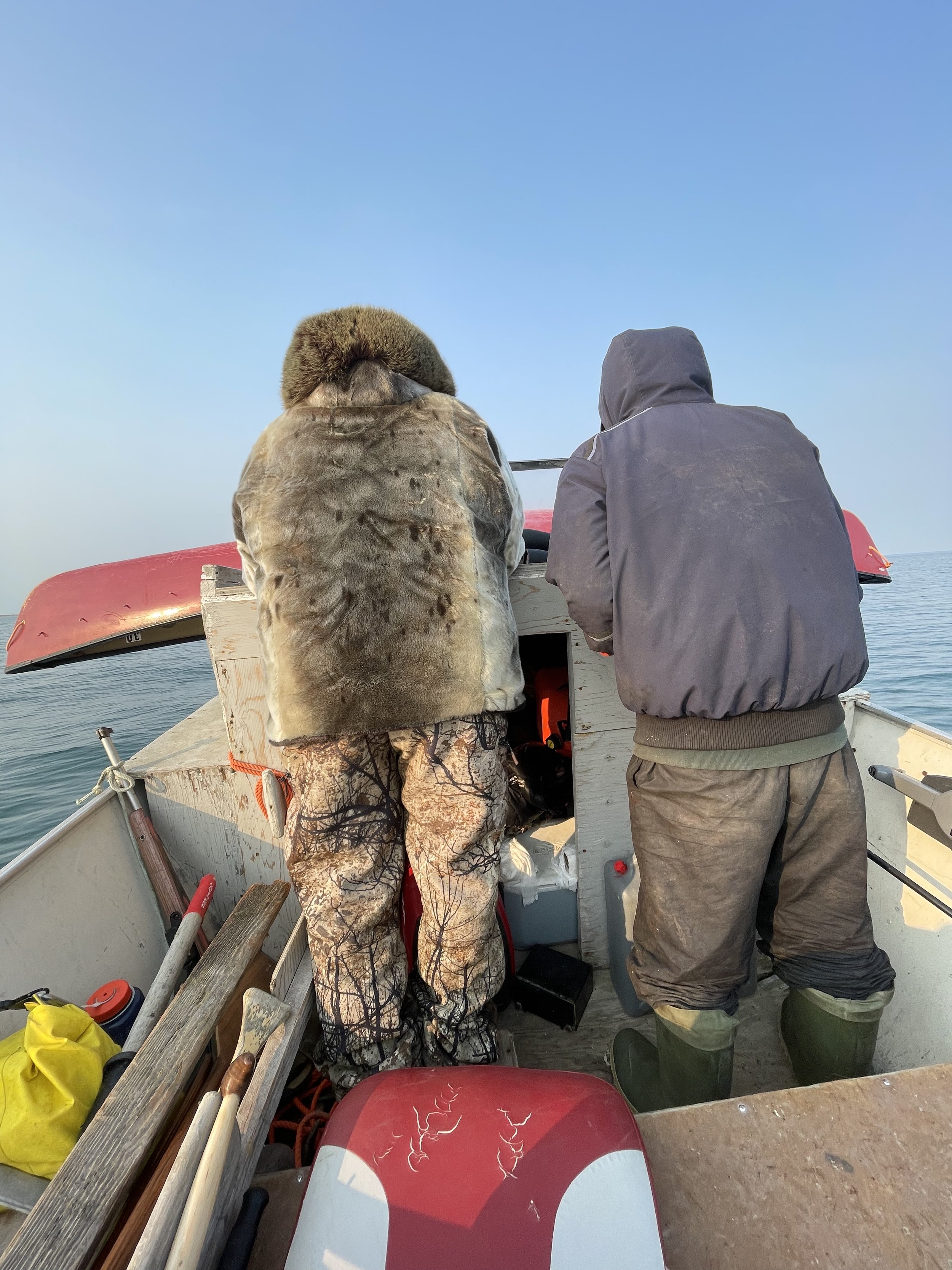
The pick up was planned to be with 2 boats for safety. We got word that further north along the shore from us was where the other boat had been camped and were waiting for us. Because we arrived in the morning, we couldn’t see their camp (nor did we know they were there yet) and because of a large rocky point, they couldn’t see our camp either. By late morning, Taylor stayed at camp, while Zach walked the shore to see if he could intercept the supposed camp down the shore. After about an hour, Zach found a white canvas tent pitched around the shore a few miles down and a boat. Here, we met Paul and Junior, two of the folks from Gjoa Haven picking us up. We got the boat brought down to the water from the low tide spot and brought it over to our camp to load up our gear, then head back to Paul and Juniors camp to get their stuff.
We enjoyed a slow morning over coffee, tea, conversation and getting the boat loaded for the long trip north. Paul and Junior spent the previous 2 days on the land and had success shooting 2 beautiful caribou the night before at camp, so in addition to our gear and theirs, we had 2 caribou loaded on the boat they brought home to their families. Finally, by around 12:30pm, we set off and headed up the east shore of the ocean for our 6 hour boat ride. We stopped occasionally in bays for breaks and to refuel, otherwise we were moving north steadily with a slight tailwind. The boat was loaded full, Taylor and Zach sitting upon the packs and caribou in the back of the boat while Paul and Anthony took turns driving.
At this point, we were keeping an eye out for Anthony and the 2nd boat that had supposedly left Gjoa Haven by now and were planning to intercept them along the way. Chantrey Inlet runs north-south and we followed the east side, then crossed to the west end towards its end. From here, there is an open water crossing through the northwest passage to King William Island to where Gjoa Haven is located. Just before this crossing, we saw a seal surface and the boat stopped. Junior grabbed his gun and was able to get a shot off at the seal, but missed just high of its head. Both Paul and Junior mentioned they are some of the few in Gjoa Haven that largely live off the land yet, so the caribou, plus the possible seal was a great bonus for them to return home with.
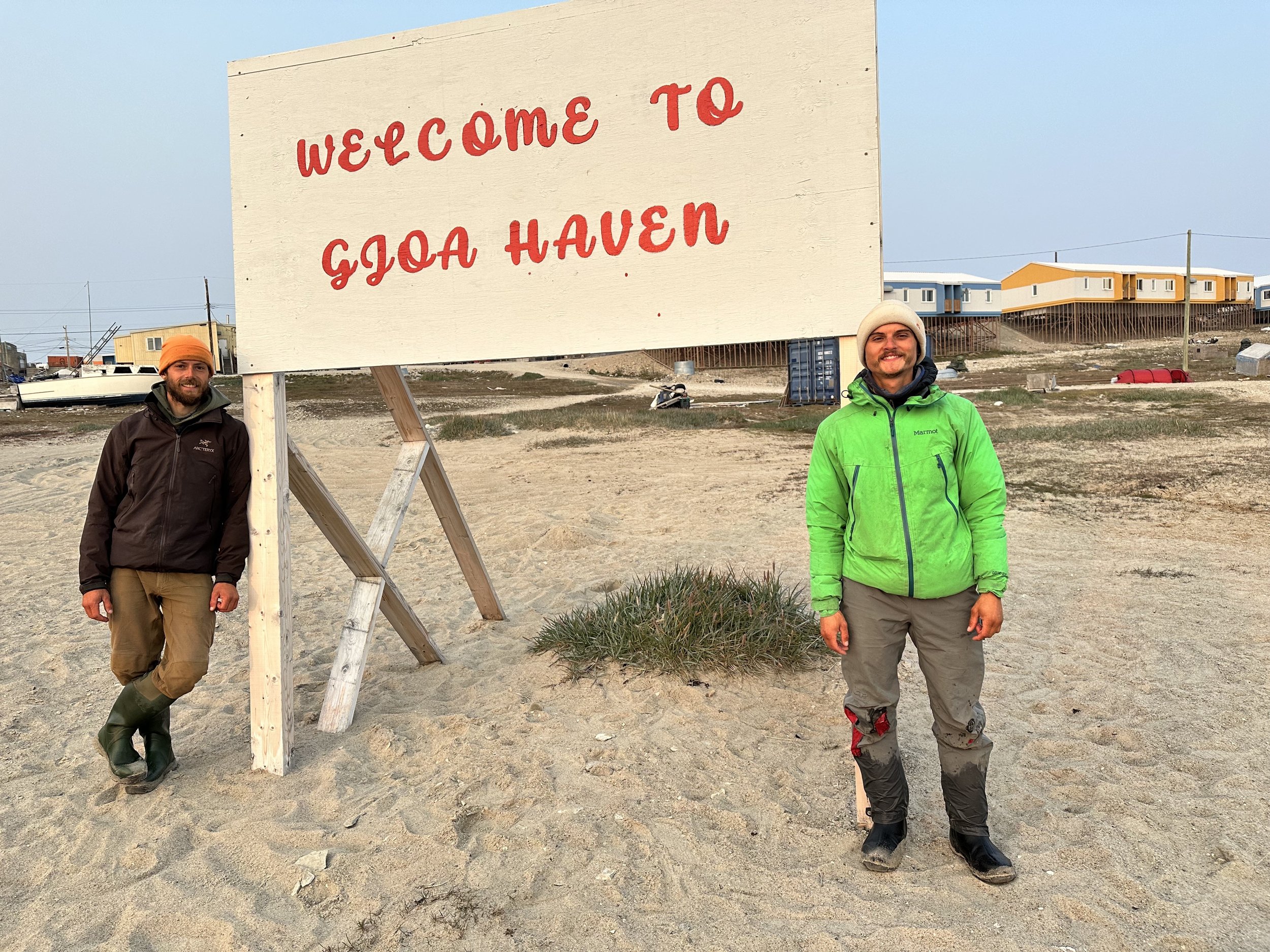
Shortly after 6pm, Gjoa Haven came into view for the first time and we landed shortly after. A long day of driving and we completed the last big stretch of water left on our route. We unloaded the boat and were met by various people from the community. We set up our tent near the shores of the coast and made our way up to the convenience store still open to fill ourselves with the treats we had been craving for months now.
Arriving back at the tent, we met Anthony, the driver of the 2nd boat. He had explained that his boat had gone all the way to the end of Chantrey Inlet and didn’t find us and had just returned. Somewhere along our routes, the two boats never saw each other and missed each other by a few miles.
We spent the next day in town walking its streets, talking to the wonderful people of the community and visiting the museum and stores. There is so much history in the town to learn about from the local Inuit culture, the lost Franklin Expedition, and the Amundson expedition, both looking for the northwest passage.
We booked our remaining flights home, something we had to wait to do until we got to town since our arrive date was so dependent on different factors. Ultimately, we needed to fly to Yellowknife, Vancouver, Chicago, then to Minneapolis
On the 21st, after a delayed flight because of a dense fog, we made the 2.5hr flight to Yellowknife, the capital of the Northwest Territories. Here we met Chuck and Muriel Tolley who graciously picked us up from the airport. We were connected to these two who have lived in Yellowknife and taught in many communities across the north for many years through mutual friends of ours. We were lucky to have these two give us an amazing tour of town after going out to eat for a delicious dinner. We were blown away by their hospitality and appreciated their kindness in showing us around their beautiful city and helping us make the most of our short time in Yellowknife. We are excited to return sometime soon!
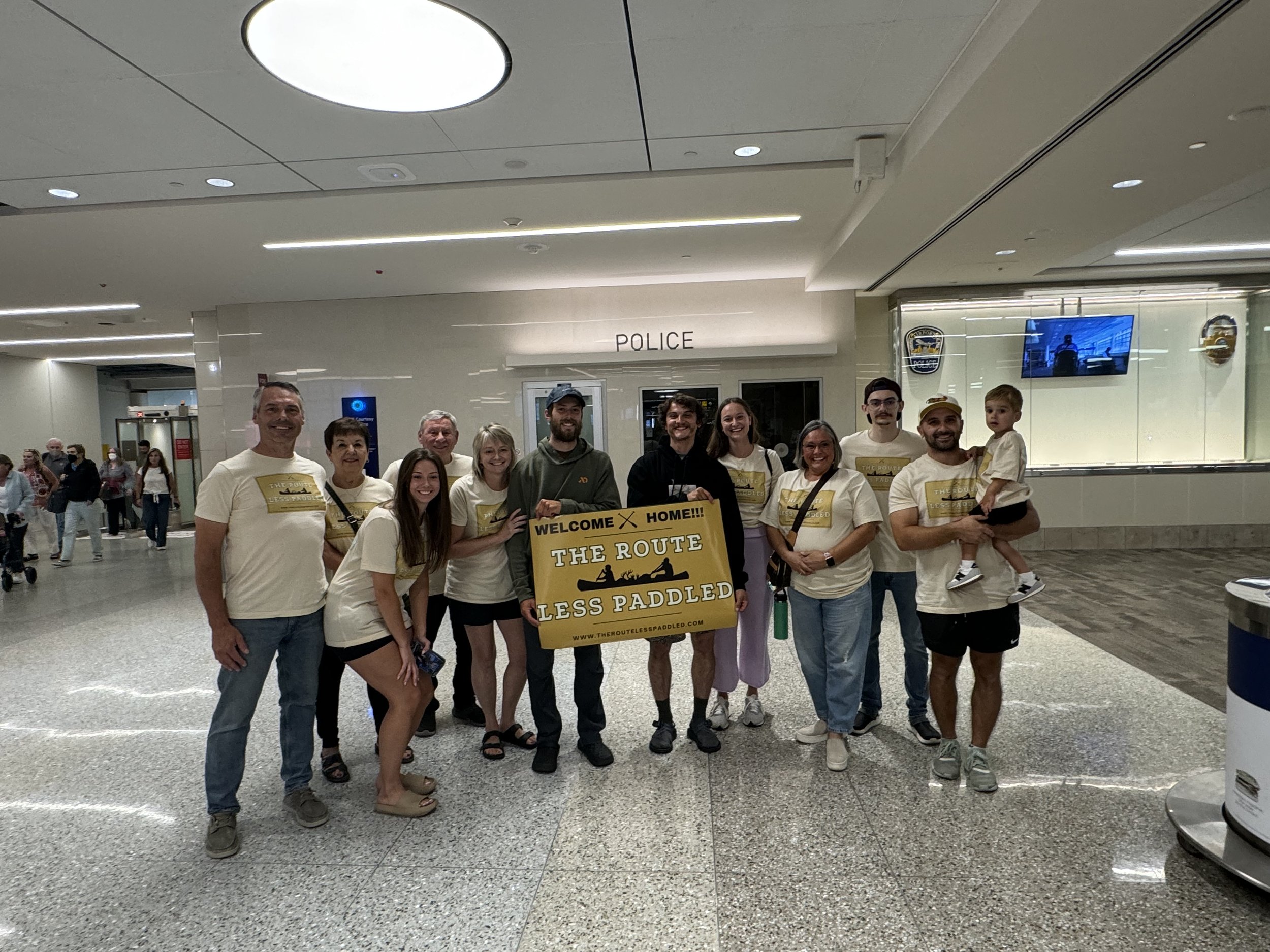
We spent the whole next day flying various stops until arriving home in MSP in the afternoon. Here, we saw family wearing matching t-shirts and a big sign to welcome us home from our journey. What a sweet surprise and homecoming it was for us. We are so grateful for their support and encouragement throughout this whole experience, we couldn’t have done it without any of them.
As we return home, we are reflecting and processing so much from these past few months. As time goes on, we will be uploading more blogs and photos from our experience to share once we get settled back in. For now, we hope you have enjoyed following us along on our expedition. We certainly had a summer we won’t ever forget. We look forward to sharing more with you all soon!